Highlights of the 2005 Season

Almost twice the area of excavation was carried out in 2005, which allowed us to take much broader look at the overall picture and also meant that we could accommodate over 60 volunteers, many faithfully returning to the site from previous years. The season produced some fascinating and complex archaeology and it was a tribute to the volunteers that they were able to understand and work with this.
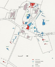
Excavation was carried out in three main areas: (See Site Plan - click to enlarge)
Area 1:The Bedrock area in the east end of the garden - Trench 33, 34 and 35
 Before the Digger arrived Philip Day thoroughly investigated the area
with the Ground Penetrating Radar
 Then the digger swiftly and efficiently cleared the upper layer of topsoil ready for the excavation.
The exposed area uncovered a series of post pits which brought our first exciting glimpse of the Medieval Period on the site in the form of a deep postpit, which yielded both pottery and a radiocarbon date suggesting between the 12th and 14th Centuries.


 The packing around the double line of postpits (used to secure each post during the construction of a building) was also found to date from between the 11th to the 13th Century. Dates from the rubble which fell into the post holes after the post had gone even tells that building was standing until between the 13th to 15th Centuries. Is it possible that we have found the beginnings of a Medieval Aisled Hall on the site?
Then amazingly A Barbed Iron Arrowhead was found in the very last week of the season in adjoining Trench 35. Experts confirm a 12th to 14th Century date, although we are not certain whether it would have been used for hunting or warfare. It seems that we are finally uncovering another strand of archaeology on the site previously confined to historical record, when a man named Roger de Meleur was the King's Forester of the Peak.
Area 2: Boulder Clay Area in the Triangular Field (Trench 36)
 The spectacular Bronze Age Dagger found at the end of the 2004 season inspired us to extend Trench 26 in case there might be other similarly ritually deposited objects in the same area.
 Excavation exposed a further complex series of intercutting pits and large numbers of what we might have thought were again Iron Age Fire Cracked
Pebbles Environmental Analysis, however, gave us further unexpected glimpses of the Late Neolithic and Early Bronze Age
periods, detecting hazelnut, burnt bone and cereal type pollen with very early Radiocarbon dates of around BC 2920 to 2650.


Area 3: Mr Arundels field beyond the Car Park(Trench 39)
Both the Ground Penetrating Radar results and two trial excavation pits confirmed the expected line of the shallow, outer boundary ditch system of the Iron Age Period.

Late Excavation (Trench 40 and 41)
In November there was a very late opportunity to follow up the trial trenches of 2004, confirming the line of the outer ditch but also investigating the first possible entranceway found in the outer ditch system.Read the full 2005 UMAU Academic Report
This page is currently under reconstruction


